Note: The following information is posted by The Hills & Districts Chamber of Commerce Inc (The Chamber) as a community service. The Chamber advises that the views, thoughts, and opinions expressed in this post belong solely to the author, and not necessarily to the Chamber, or a committee or other group or individual associated with the Chamber.
From: Kris Spann <Kris.Spann@moretonbay.qld.gov.au>
Sent: Friday, 13 May 2022 6:34 AM
Subject: Severe Weather Update
Good morning Business Leaders,
As the current severe weather situation develops, you and your business community are advised to utilise the following trusted sources of information to keep across developments:
- Council’s Disaster Portal hosts live information on road closures, dam releases, sandbag locations, evacuation centres and more Disaster portal – Moreton Bay Regional Council
- Businesses should register for SMS updates at MoretonAlert MoretonAlert – Moreton Bay Regional Council
- Check the Bureau of Meteorology’s Queensland warnings summary at Queensland Warnings Summary (bom.gov.au)
- Weather impacted roads (currently 94 closed roads at this time) can be monitored here
- Live river height information is available here: River Height Bulletin – Brisbane, Bremer (QLD) (bom.gov.au)
- Council has an online guide to prepare yourself and your business for a flooding event
Situation and Warning Summary
- The Bureau of Meteorology has now issued Flood Watch No. 1 for possible minor to moderate flooding impacts within the region during the next couple of days based on forecast rainfall.
- Worst case rainfall predictions over the next 24 hours are in excess of 100mm for parts of the region
- All catchments are now considered very wet, so any further rainfall will lead to more rapid water level rises.
- 16 MoretonAlert flood warnings have been issued by Council for locations including Beachmere, Burpengary, Caboolture, Dayboro, Deception Bay, Eatons Hill, Elimbah, Kobble Creek, Moodlu, Toorbul and Woodford.
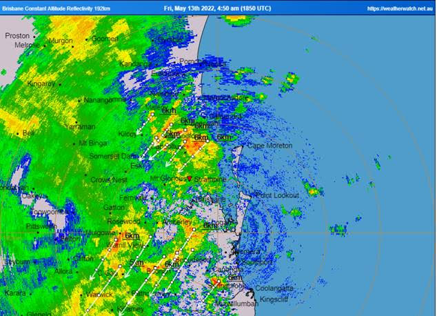
The current ‘Weather Watch’ situation update as at 5:40am is as below.
Further heavy falls are likely today, and while heavy falls remain a threat across all of the Southeast Coast district, it continues to be a higher threat over the northern and western areas of the district (north and west of a line approximately from Boonah to Brisbane) and this remains the main area of concern today. Further falls exceeding 100-150mm (some local areas potentially 200mm+) are expected during the next 12-18 hours. This is likely to at least maintain, and likely contribute to the current flooding over these areas during this time. Conditions should ease overnight tonight, though showery conditions will still be present tomorrow across the Southeast Coast region. In addition, this trough is producing locally squally wind gusts and gale force wind gusts hasve been observed with some of the heavier showers.
Council Disaster Portal snapshot as at 5:30am:
Please keep yourself and your business community informed during this situation as it continues to develop.
Most importantly, stay safe.
#TeamMoretonBay
We respectfully acknowledge the Traditional Country across our region.
We also acknowledge and pay our respects to the Kabi Kabi, Jinibara and
Turrbal Traditional Custodians, and their elders past, present and emerging.
MORETON BAY REGIONAL COUNCIL (MBRC) PRIVILEGED PRIVATE AND CONFIDENTIAL – The information contained in this e-mail and any attachments is confidential and may attract legal privilege. It is only intended for the named recipient/s. If you are not a named recipient any use of this information including copying, distribution and publication is prohibited. Confidentiality and legal privilege are not waived or lost as a result of mistaken or erroneous delivery. If you are not a named recipient, please delete all copies immediately and contact the sender to advise of the error.
It is recommended that you scan this email and any attachment before opening. MBRC does not accept any responsibility or liability for loss or damage arising directly or indirectly from opening this email, opening any attachments or any communication errors.
The views expressed in this email and any attachments are the personal views of the sender unless otherwise stated.


